If you're in the UK, you can now view our appearance in 'The Universe in a Snowflake' on the BBC iPlayer:
http://www.bbc.co.uk/iplayer/episode/b07k7m4z/forces-of-nature-with-brian-cox-1-the-universe-in-a-snowflake
The segment on icebergs in which we appear begins at 41:44 and runs to 51:44. The documentary is available for the next 29 days.
Monday, 4 July 2016
Saturday, 2 July 2016
Appearance in BBC documentary

We are excited to reveal that the the Autonomous Oceans System Lab of Memorial University will be appearing in the first episode of a new BBC TV series called 'Forces of Nature with Brian Cox'. The episode, entitled 'The Universe in a Snowflake', will be shown in the UK this Monday evening (July 4th, BBC One at 9pm). We feature in the segment on icebergs.
US viewers will be able to catch the show on PBS in the near-future (details to follow).
Monday, 15 February 2016
Labrador Sea 2015 Mission update: Lost contact

The glider's last known location
before contact was lost (Jan 27th 2016)

If you spot a glider how can you tell it's this lost one? The lost glider is unique in having a sensor mounted on the front, with a black cable running back from it along the outside of the hull. It also has Memorial University of Newfoundland (MUN) logos at the forward and aft ends.

Distinguishing features of the lost glider
The MUN logo
Saturday, 23 January 2016
Labrador Sea 2015 Mission update: A leak sparks a rescue attempt
Things haven't exactly worked out as planned with our LabSea 2015/16 glider mission. Unforunately shortly after getting off the continental shelf into the central Labrador Sea and starting deep dives (to 1000m), our mission glider sprang a leak. As seawater and electronics don't mix, it is preferable in these situations to recover the vehicle as soon as possible. However, this having been December in the Labrador Sea, our recovery options were limited.
But as luck would have it, on December 3rd, the CCGS Hudson, a Canadian Coast Guard science vessel happened to be in the vicinity. The Hudson was on an Atlantic Zone Monitoring Program (AZMP) cruise, and having just completed the final AZMP sampling transect (the Seal Island line off southern Labrador), was on its way back to its Halifax home base. The ship's captain graciously agreed to steam over to our glider and assess whether recovery was feasible.
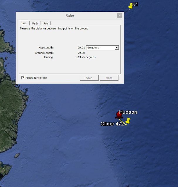
With the weather conditions being too rough to launch the Hudson's small inflatable 'fast rescue' craft, an impromptu attempt was instead made to snare the glider using lines thrown from the Hudson. Ultimately, despite coming close to getting a line around it, this proved too difficult and the rescue attempt had to be abandoned. We do, however, remain grateful for their heroic efforts.
With no remaining options for ship-based recovery, our attention turned to trying to fly the glider back in towards land, despite the leak. This idea was soon dashed, however, when the glider's fin (which controls its heading) stopping working a few hours after the Hudson's rescue attempt. Although not caused by the latter, this was unfortunate timing. With the fin out-of-order, we could no longer send the glider in a particular direction. It would simply go round in circles when flown.
Have exhausted all our recovery options, we were forced to leave the glider drifting at the surface. And this is what it's been doing ever since, while calling in each hour with GPS position updates.

Where exactly the winds and currents will take our glider now, we don't know. Messages in bottles launched over the past few years from Newfoundland and tracked on yourmessageinabottle.com can serve as some guide. Those that have made landfall (and been found) have tended to drift east across the north Atlantic, reaching as far north as Scotland and as far south as the Canary Islands.
You can post your guess for where you think our glider will next come near land in the comments below, then follow the glider's path in real-time here to see if you're right:
But as luck would have it, on December 3rd, the CCGS Hudson, a Canadian Coast Guard science vessel happened to be in the vicinity. The Hudson was on an Atlantic Zone Monitoring Program (AZMP) cruise, and having just completed the final AZMP sampling transect (the Seal Island line off southern Labrador), was on its way back to its Halifax home base. The ship's captain graciously agreed to steam over to our glider and assess whether recovery was feasible.

Once it became clear the CCGS Hudson would pass close to the glider, we put in a request for recovery.
With the weather conditions being too rough to launch the Hudson's small inflatable 'fast rescue' craft, an impromptu attempt was instead made to snare the glider using lines thrown from the Hudson. Ultimately, despite coming close to getting a line around it, this proved too difficult and the rescue attempt had to be abandoned. We do, however, remain grateful for their heroic efforts.
With no remaining options for ship-based recovery, our attention turned to trying to fly the glider back in towards land, despite the leak. This idea was soon dashed, however, when the glider's fin (which controls its heading) stopping working a few hours after the Hudson's rescue attempt. Although not caused by the latter, this was unfortunate timing. With the fin out-of-order, we could no longer send the glider in a particular direction. It would simply go round in circles when flown.
Have exhausted all our recovery options, we were forced to leave the glider drifting at the surface. And this is what it's been doing ever since, while calling in each hour with GPS position updates.

The glider's journey so far.
Where exactly the winds and currents will take our glider now, we don't know. Messages in bottles launched over the past few years from Newfoundland and tracked on yourmessageinabottle.com can serve as some guide. Those that have made landfall (and been found) have tended to drift east across the north Atlantic, reaching as far north as Scotland and as far south as the Canary Islands.
You can post your guess for where you think our glider will next come near land in the comments below, then follow the glider's path in real-time here to see if you're right:
Friday, 20 November 2015
Labrador Sea 2015 Glider Testing and Deployment

Testing the glider in the bay off Charlottetown. Robin controlled the glider from a van onshore while the rest of the team were out watching from a skiff.
Photo credit: Mark Downey

Lowering the glider into the water off the dock in Charlottetown for a final check on science sensors.
Testing complete, it was time to deploy.
Photo credit: Robin Matthews

Sunrise on deployment day in Port Hope Simpson (where we were staying), down the road from Charlottetown.
Photo credit: Robin Matthews

Snowflakes on our van window.
Photo credit: Robin Matthews

Charlottetown harbour with our deployment vessel, Little Bubbles tied up to the dock on the left. As can be seen in the foreground, ice is starting to form around the edge of the bay. In only a few more days the harbour may be completely frozen over and Little Bubbles won't be able to get off the dock. So we're deploying just in the nick of time!
Photo credit: Robin Matthews

Close up of Little Bubbles.
Photo credit: Mark Downey

The deployment team - from left to right: Brian, Everett, Mark and Robin.
A big thanks to Everett and Brian for use of their vessel and testing/deployment assistance.
Photo credit: Darlene Turnbull

The path out to our offshore deployment location from Charlottetown was riddled with numerous small islands, many separated only by narrow passages containing treacherous submerged rocks. Fortunately our experienced local crew knew the route to take to avoid these underwater hazards and navigated us out into open waters with ease. It won't be long now before this area is frozen solid and you can walk out to the islands.
Photo credit: Mark Downey

Deployed! We slid the glider off its cart into the water over the side of Little Bubbles in the manner of a kid going down a slide. It shot down beneath the surface before bobbing back up again (to our relief).
Photo credit: Mark Downey

Robin sends the glider on its way from the cockpit of Little Bubbles.
Photo credit: Mark Downey

Back in Charlottetown, Little Bubbles had to cut a path through the ice in order to get back to the dock. This made a disconcerting crunching noise on the boat's fibreglass hull.
Photo credit: Robin Matthews
Thursday, 19 November 2015
Off to Labrador: Day Three
In the final outbound leg of our journey to Charlottetown we travelled up the Trans-Labrador Highway.

The majority of the highway is gravel road. The stretch up to Charlottetown wasn't completed until 2001. Before that such coastal towns could only be reached by air or sea.

The highway passes through boreal forest.

The highway passes through boreal forest.


Entering the town of Capstan Island. The town takes its name from a small island offshore upon which a capstan (a rotating post - originating on sailing ships) was erected to wind in a rope running from the mainland. The line opened the door of a seal trap, designed to catch seals as they migrated through the area in springtime.

Mammoth in the town of Red Bay.

Frozen river.

Charlottetown. Notice the sledge, which is used to transport materials behind ski-doos in winter.

Another sign full-on winter is on its way. Charlottetown locals have already stockpiled firewood for their wood stoves.
LabSea 2015 Map
View track:
Mission started: November 19th 2015
Plugin not working?: It won't work in the 64 bit version of Chrome or Internet Explorer 10+. Try another browser (e.g. Firefox).
Subscribe to:
Comments (Atom)